


၏ ရွင္းလင္းခ်က္ Polaris GPS Navigation: Hiking, Marine, Offroad
Easy-to-use high performance GPS for wherever your travels take you. No account setup or subscriptions required.
Turn your phone into a powerful GPS navigation system with Polaris Navigation GPS, the world's #1 all-purpose GPS, and dare to go where there are no roads.
Imagine... What would it be like to navigate any waterway or explore any wilderness or city using only your phone's GPS location abilities and a view of the sky? What it would be like to create navigation destinations without the need of an internet connection and find them using only an arrow or offline maps.
That is just a glimpse of the navigational power you will hold in your hands when you install Polaris Navigation GPS.
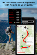
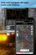
Used mostly as a hiking, off road, nautical and trail GPS app, Polaris is an excellent backup or replacement for your handheld dedicated GPS satellite navigation unit and will keep you oriented wherever your outdoor adventures take you!
Typical usage:
● Hiking GPS with the best hiking maps!
● Back country exploration and outdoor adventure
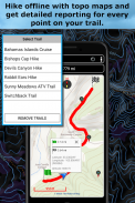
● Trail recorder
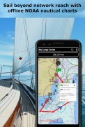
● Sailing, Boating. All marine navigation charts in Polaris are free.
● Fishing GPS. Find you favorite fishing hole.
● Hunting and hunting maps. Find you favorite hunting blind and your way back!
● Geocache
● Camping
● Mountain Biking and bike maps
● Backpacking and other outdoor sports
● Compass orienteering
Known for its stability, reliability and flexibility, Polaris is used by land-sea search and rescue, military personnel and millions of others worldwide.
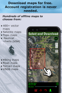
To support your offline adventures we provide free of charge:
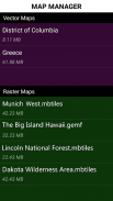
📡 Access to our vector & raster map downloaders (topos, marine, hiking and others).
📡 No limits on map types or on the number of map downloads.
📡 All maps are shown with high detail and large, easy to read labels.
This powerful navigation system also includes:
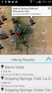
📡 Polaris Places Picker. Find hiking trails, camping locations and much more!
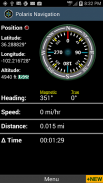
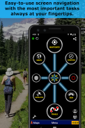
📡 GPS compass and magnetic compass
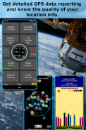
📡 GPS parameters panel
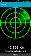
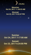
📡 Odometers, altimeters, speedometers, chronometers
📡 Split distances on tracks
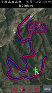
📡 Draw a trail and navigate it
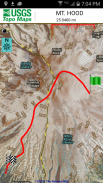
📡 Google Maps, OpenStreetMap-Mapnik, Topographic Maps, Cycle Route and Hiking Maps, Vector Maps, USGS Topo Maps, NOAA Marine Charts, World Aviation Operations Charts, Canada Toporama.
📡 Comprehensive set of GPS Tools and diagnostics
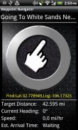
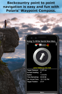
📡 Waypoint navigation system including a dynamic waypoint-finding compass that always points to your destination while reporting estimated time of arrival, distance to target and other statistics. Just follow the arrow!
📡 Trail navigation system
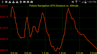
📡 Altitude profiles
📡 Location sharing
📡 Supports British OSGR and OSGB-36 DATUM (Ordnance Survey Grid)
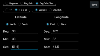
📡 Coordinate formats: latitude/longitude as degrees, deg:min, deg:min:sec, and UTM (Universal Transverse Mercator).
📡 Military Coordinate Finder - Military Grid Coordinate Reference System (MGRS).
📡 Hiking Trails - Most of the maps show hiking paths courtesy of the Openstreetmap project. We are always amazed to find that even some of the most obscure hiking routes in our state are available.
⚓ Marine navigation- NOAA Nautical Charts and nautical unit reporting.
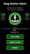
⚓ Drift alert / Drag anchor alarm.
📡 Select source for altitude reporting: Satellites, United States Geologic Survey or map your location to the results of NASA's Space Shuttle Radar Topography Mission
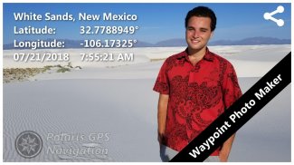
📡 Waypoint photography.
📡Map Search and Coordinate Conversion capabilities with the free MapIt! plug-in
📡 Improved compatibility for maritime navigation with addition of nautical and NOAA marine charts.
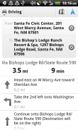
📡 Road navigation and street directions are provided through a digital pipeline connecting the power of Polaris to the Google Maps app on your device.
* The premium version of Polaris Navigation is called GPS Waypoints Navigator, available on Google Play. GPS Waypoints Navigator is ad-free and contains many other enhancements.
လွယ်ကူ-to-ကိုသုံးပါသင့်ရဲ့ခရီးသွားမှတ်တမ်းကိုသင်ယူနေရာတိုင်းမှာအဘို့အမြင့်မားသောစွမ်းဆောင်ရည် GPS စနစ်။ အဘယ်သူမျှမအကောင့် setup ကိုသို့မဟုတ် subscriptions ကိုလိုအပ်သည်။
Polaris Navigation GPS စနစ်, ကမ္ဘာ့ # 1 All-ရည်ရွယ်ချက်ဂျီပီအက်စ်နှင့်အတူအစွမ်းထက် GPS စနစ် navigation system ကိုစသင့်ရဲ့ဖုန်းကိုဖွင့်ပါနှင့်မျှလမ်းများရှိပါတယ်ဘယ်မှာမသွားဝံ့။
ဒါကြောင့်မည်သည့်ရေလမ်း navigate သို့မဟုတ်မှသာဖုန်းရဲ့ GPS တည်နေရာအရည်အချင်းများနှင့်မိုဃ်းကောင်းကင်၏တစ်ဦးအမြင်သုံးပြီးမည်သည့်တောအရပ်သို့မဟုတ်မြို့စူးစမ်းတူအဘယ်အရာပါလိမ့်မယ် ... စဉျးစားကွညျ့? အဘယ်အရာကိုကအင်တာနက်ချိတ်ဆက်မှုမလိုဘဲအညွှန်းတွင် Destinations ကိုဖန်တီးရန်ကဲ့သို့ဖြစ်သာတစ်ဦးမြှားသို့မဟုတ်အော့ဖ်လိုင်းမြေပုံများကို အသုံးပြု. သူတို့ကိုတွေ့ပါလိမ့်မယ်။
ဆိုလိုသည်မှာသင်သည် Polaris Navigation GPS စနစ်ကိုထည့်သွင်းတဲ့အခါမှာသင်သည်သင်၏လက်၌ကိုင်ထားမည်သွားလာမှုအာဏာရုံတစေ့တစောင်းဖြစ်ပါတယ်။
အများအားဖြင့်တစ်တောင်တက်, လမ်းပိတ်ထား, ရေကြောင်းနှင့်လမ်းကြောင်း GPS စနစ် app ကိုအဖြစ်အသုံးပြု, Polaris သင့်ရဲ့လက်ကိုင်ဆက်ကပ်အပ်နှံဂျီပီအက်စ်ဂြိုဟ်တုအညွှန်းယူနစ်များအတွက်အလွန်အစွမ်းထက်တဲ့ backup လုပ်ထားသို့မဟုတ်အစားထိုးဖြစ်ပါတယ်နှင့်သင့်ပြင်ပတွင် Adventures သငျသညျယူနေရာတိုင်းမှာ oriented သငျသညျစောငျ့ရှောကျမညျ!
ပုံမှန်အသုံးပြုမှု:
●ကိုအကောင်းဆုံးတောင်တက်မြေပုံနှင့်အတူတောင်တက် GPS စနစ်!
●သို့ပြန်သွားရန်တိုင်းပြည်ရှာဖွေရေးနှင့်ပြင်ပစွန့်စားမှု
● Trail အသံဖမ်း
●ရွက်လွှင့်လှေ။ Polaris အားလုံးအဏ္ဏဝါအညွှန်းဇယားအခမဲ့ဖြစ်ကြသည်။
●ငါးဖမ်း GPS စနစ်။ သငျသညျအကြိုက်ဆုံးငါးဖမ်းပေါက်ကိုရှာပါ။
●အမဲလိုက်ခြင်းနှင့်အမဲလိုက်မြေပုံ။ သငျသညျအကွိုကျဆုံးအမဲလိုက်မျက်စိကန်းနှင့်သင့်လမ်းကိုပြန်ရှာပါ!
● Geocache
●စခန်း
●လမ်းကြမ်းစက်ဘီးစီးပြိုင်ပွဲနှင့်ဆိုင်ကယ်မြေပုံ
●ကျောပိုးအိတ်ခရီးထွက်နှင့်အခြားပြင်ပအားကစား
● Compass ခြေလျှင်လမ်းလျှောက်ပွဲ
ယင်း၏ တည်ငြိမ်မှုများအတွက်မသိ, ယုံကြည်စိတ်ချရနှင့်ပြောင်းလွယ်ပြင်လွယ် Polaris ကမ္ဘာတစ်ဝှမ်းတွင်အခြားသူများ၏မြေပင်လယ်ရှာဖွေရေးနှင့်ကယ်ဆယ်ရေး, စစ်ရေး်ထမ်းများနှင့်သန်းပေါင်းများစွာကအသုံးပြုသည်။
ကျနော်တို့တာဝန်ခံအခမဲ့ပေးသင့်ရဲ့အော့ဖ်လိုင်း Adventures ကိုထောကျပံ့ရန်:
📡ကျွန်တော်တို့ရဲ့အားနည်းချက်ကို & အကြောင်းအရာအကြမ်းမြေပုံဒေါင်းလုပ် (topos, အဏ္ဏဝါ, တောင်တက်နှင့်အခြားသူများ) ကို Access ကို။
📡မြေပုံအမျိုးအစားများပေါ်တွင်သို့မဟုတ်မြေပုံ downloads, ၏နံပါတ်ပေါ်အဘယ်သူမျှမကန့်သတ်။
📡အားလုံးမြေပုံများအားမြင့်မားတဲ့အသေးစိတ်နဲ့ကြီးမားတဲ့ဖတ်ရန်လွယ်ကူတံဆိပ်များနှင့်အတူပြသလျက်ရှိသည်။
ဤသည်အစွမ်းထက် navigation system ကိုလည်းပါဝင်သည်:
📡 Polaris နေရာများကောက်ယူသူ။ လမ်းကြောင်း, စခန်းချနေထိုင်မည့်နေရာများနှင့်ပိုပြီးတောင်တက်ရှာဖွေလိုက်ပါ!
📡 GPS စနစ်သံလိုက်အိမ်မြှောင်နှင့်သံလိုက်အိမ်မြှောင်
📡 GPS စနစ် parameters တွေကို panel က
📡 Odometers, altimeters, အမြန်နှုန်းမီတာ, ကို Chronometer
အပုဒ်ပေါ် Split ကိုအကွာအဝေး📡
တစ်လမ်းကြောင်းဆွဲပါနှင့်သွားလာ📡
📡 Google Maps ကို, OpenStreetMap-Mapnik, မြေမျက်နှာသွင်ပြင်မြေပုံများ, Cycle လမ်းကြောင်းနှင့်တောင်တက်မြေပုံများ, Vector မြေပုံများ, USGS Topo မြေပုံများ, NOAA အဏ္ဏဝါဇယား, ကမ္ဘာ့လေကြောင်းစစ်ဆင်ရေးဇယား, ကနေဒါ Toporama ။
ဂျီပီအက်စ် Tools များနှင့်အမှား၏📡ဘက်စုံ set ကို
ဆိုက်ရောက်, ပစ်မှတ်ထားဖို့အကွာအဝေးနှင့်အခြားစာရင်းဇယားများ၏ခန့်မှန်းခြေအချိန်သတင်းပို့စဉ်အမြဲသင့်ရဲ့ဦးတည်ရာကိုညွှန်ပြနေတာတဲ့ပြောင်းလဲနေသောအမှတ်များရှာဖွေရေးသံလိုက်အိမ်မြှောင်အပါအဝင်📡အမှတ် navigation system ကို။ ရုံမြှားနောက်ကိုလိုက်!
📡 Trail navigation system ကို
📡မြင့် profile များကို
📡တည်နေရာမျှဝေမှု
📡ဗြိတိန် OSGR နှင့် OSGB-36 DATUM (အမြောက်တပ်ဖွဲ့စစ်တမ်း Grid) ထောက်ပံ့
📡ကို formats Coordinate: လတ္တီဒီဂရီအဖြစ် / လောင်ဂျီတွဒ်, deg: မိ, deg: မိ: စက္ကနှင့် UTM (Universal Transverse Mercator) ။
📡စစ်ဘက်ဆိုင်ရာ Finder ကို Coordinate - စစ်ရေး Grid ကိုးကားစရာစနစ် (MGRS) Coordinate ။
📡လမ်းကြောင်းခြေလျင်ခရီး - မြေပုံအများစုမှာ OpenStreetMap စီမံကိန်း၏တောင်တက်လမ်းခရီးယဉ်ကျေးပြသပါ။ ကျနော်တို့ကအမြဲပင်အချို့ကျွန်တော်တို့ရဲ့ပြည်နယ်အတွက်အများဆုံးထင်ရှားတဲ့တောင်တက်လမ်းကြောင်း၏ရရှိနိုင်ပါသည်ကွောငျးတှေ့ဖို့အံ့သြနေကြသည်။
⚓အဏ္ဏဝါ NOAA ရေကြောင်းဇယားများနှင့်ရေကြောင်းယူနစ်အစီရင်ခံ navigation- ။
တပ်လှန့် / ဆွဲကျောက်ဆူးနှိုးဆော်သံပျံ့⚓။
အမြင့်အစီရင်ခံဘို့📡ကို Select လုပ်ပါအရင်းအမြစ်: ဂြိုဟ်တုအမေရိကန်ပြည်ထောင်စုဘူမိဗေဒသို့မဟုတ်နာဆာရဲ့အာကာသ Shuttle Radar မြေမျက်နှာသွင်ပြင်မစ်ရှင်၏ရလဒ်များကိုမှသင့်တည်နေရာကိုမြေပုံ
📡အမှတ်ဓာတ်ပုံနဲ့။
အခမဲ့ MapIt နှင့်အတူကူးပြောင်းခြင်းစွမ်းရည်ရှာရန်နှင့် Coordinate 📡Map! plug-in ကို
ရေကြောင်းနှင့် NOAA အဏ္ဏဝါဇယား၏ထို့အပြင်နှင့်အတူရေကြောင်းအညွှန်းများအတွက်📡တိုးတက်လာသောလိုက်ဖက်တဲ့။
📡လမ်းမကြီးရေကြောင်းသွားလာမှုနှင့်လမ်းပေါ်လမ်းညွန်သင့်ရဲ့ device ကိုအပေါ်ကို Google Maps app ကိုမှ Polaris ၏တန်ခိုးကိုဆက်သွယ်မယ့်ဒစ်ဂျစ်တယ်ပိုက်လိုင်းမှတဆင့်ထောက်ပံ့ပေးလျက်ရှိသည်။
* Polaris Navigation ၏ပရီမီယံဗားရှင်း Google Play ပေါ်တွင်ရရှိနိုင်ပါသည်, GPS, အမှတ် Navigator ဟုခေါ်သည်။ ဂျီပီအက်စ်အမှတ် Navigator အခမဲ့ကြော်ငြာသည်နှင့် များစွာသောအခြားတိုးမြှင့်မှုများပါရှိသည်။
Polaris GPS Navigation: Hiking, Marine, Offroad - ဗားရွင္း 9.25
(30-01-2024)
Polaris GPS Navigation: Hiking, Marine, Offroad - APK သတင္းအခ်က္အလက္
APK ဗားရွင္း: 9.25package: com.discipleskies.android.polarisnavigationPolaris GPS Navigation: Hiking, Marine, Offroad ၏ ေနာက္ဆုံးဗားရွင္း
က႑တူအက္ပ္မ်ား
သင္ႏွစ္သက္ႏိုင္သည္မ်ားမွာ...


